 |
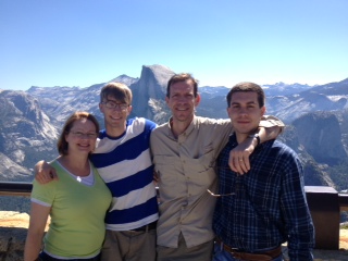
| At the top of Glacier Point in Yosemite National Park. |
Also, none of us fell off a mountain, drove into the ocean or were run over by a cable car.
I did get hit in the head by a rock, but more about that later. (Skip ahead to day 7 if you just can't wait.)
What follows is a day-by-day summary of our trip for those who care to experience it vicariously. I had hoped to write this at the end of each day, but at that point I was too exhausted. So before the smaller yet important details become overshadowed by the bigger ones, I will try to remember all I can.
No doubt the best way to experience these places, if you've never experienced them before, is to experience them yourself.
Day 1: Rock Island, Ill., to Chowchilla, Calif.
After dropping off our beloved Chihuahua, Remi, at my mother-in-law's, we drove from our home in Rock Island, Ill., to Chicago to catch our plane to San Francisco. The flight was the first for our 23- and 19-year-old sons, and the first for me and my wife since 9/11.
We navigated the added security just fine -- even my younger son, who was hoping that the two surgical steel bars in his chest would set off the alarm and provide him with a good story to tell his friends.
Note to frustrated terrorists: If you wish to smuggle large, blunt pieces of metal onto an airplane, have two bars surgically implanted under your rib cage. Not sure how you're going to extract these once on the plane, but you figure it out. You're the terrorist, not me.
 |
| Val's Burgers, Hayward, Calif. |
We had some time to cool our heels and explore O'Hare airport for awhile, then we boarded our Virgin America plane. It was a great flight, and my sons were thrilled by the experience. I "made a friend" (as my family likes to say when I strike up long conversations with strangers) with Gregory (last name unknown), who was sitting next to me in the aisle seat. Gregory and his wife were returning to their home in Santa Rosa, Calif., and he and I talked quite a bit about, well, just about everything. In four hours in an airplane you can cover a lot of ground -- literally and figuratively.
Once on the ground in San Francisco, we picked up our rental car and drove across the San Mateo Bridge. We were to spend the first few days of our trip in Yosemite, and the first night we had to get as far as our hotel in Chowchilla, about two-thirds of the way to the park.
We first stopped for dinner at Val's Burgers, a popular vintage 1950s burger/malt shop in Hayward, just across the bay. Busy place. Great food.
Then it was on to Chowchilla, where we crashed (figuratively speaking) after an exhausting day of car travel, plane travel, and then more car travel.
Day 2: Vernal Fall
 |
| Vernal Fall |
Shortly before noon we arrived at Cedar Lodge, just west of El Portal. Too early to check in and having just missed the shuttle into the park, we drove on to Yosemite. Gawking our way past El Capitan and Yosemite Falls, we drove through the valley to the village, where we claimed one of the last remaining day-use parking spots. It was Saturday, June 15, at the beginning of the crowded summer tourist season. The towering waterfalls, mountains and massive granite walls served to minimize the humanity -- even in such great number. After getting our bearings and grabbing some pizza for lunch, we chatted with a park guide who sized us up and suggested a hike up Mist Trail to Vernal Fall. A short shuttle ride later, we began our ascent.
Just a few minutes into the hike we were confronted with the reality of the danger the park presents to visitors. Several hikers were running down from the trail above, shouting for someone to call 9-1-1. A hiker had collapsed or fallen (we weren't sure which) farther up the trail and was being given CPR. Minutes later we passed a huddled group tending to the man, who by that time was breathing on his own but clearly was in distress.
We don't know what happened to him before or after the incident -- but he was not elderly and appeared to be in fairly good shape.
Meanwhile, other people who appeared not to be in good shape trudged up the trail without incident.
This was a gorgeous hike, and quite strenuous for our first day in the park. Though paved (which surprised us), the trail is quite steep and rises 400 feet over eight-tenths of a mile from the trailhead to the footbridge. From there it rises another 600 feet over the final seven-tenths of a mile to the top of Vernal Fall. We went to the base of the fall but did not ascend the final leg of the trail, a treacherous series of rock steps made slippery by the cool, refreshing mist from the roaring fall, bathing everything and everyone. Instead we joined other hikers standing along the edge of the trail like mountain goats, trying to find a place to gain a foothold as others passed by on their way up or down.
Later I learned that in May a 73-year-old man had fallen to his death from the ledge atop the fall, presumably while taking a photo (there were no eye witnesses, but his backpack, found at the top of the fall, was missing his camera). Another three women, all friends, fell to their deaths in the same area.
We saw people everywhere in the park taking photos from precarious locations, atop stone walls, ledges, outcroppings, you name it. I took my photo of Vernal Fall (above) from about the mid-point of the steps leading up the final stretch.
Going down the trail was much quicker than going up, of course, but even so the entire excursion took us about two and a half hours.
Since it was already after 5 p.m. and we were tired and hungry, we headed back to our lodge, checked in and then had dinner at the bar and grill. I got a locally brewed beer at the bar and struck up a conversation with the bartender, who to my surprise actually knew where our hometown was, and whose father was from Wisconsin, same as mine.
 As we left the restaurant we met a little Chihuahua named Oscar, who was tied up outside the side door while his owner ate inside. Oscar was very friendly but was intent on keeping his owner in sight. Typical Chihuahua.
Meanwhile, Ben found himself surrounded by bears outside on the lodge grounds. Fortunately, these were bears carved out of wood, placed here, there and everywhere. For fun, Ben took all their photos wearing a baseball cap from his high school alma mater.
We had tons of space in our room, which actually consisted of a living room with fold-out couch, a dining area, a bedroom with two queen beds. Off the bedroom our second-floor balcony overlooked the Merced River across the highway and the hills beyond. Great spot for a beer at the end of a busy, wonderful day.
Our first and only full day in Yosemite began with me reaching to shut off the 6 a.m. alarm and in the process breaking my glasses lying on the nightstand.
With a piece of Scotch tape from the front desk, I was able to reattach the arm at the broken hinge.
Dorky, yes, but at least I could see -- and there was a lot to see.
First things first -- an incredible buffet breakfast at the lodge restaurant, with our waitress, Earlene, being a dead ringer for the actress Judy Dench.
Outside the restaurant I encountered a couple who appeared uncertain about where to enter, or perhaps what was on the menu. "Go right in those doors," I said. "They've got a fantastic buffet."
The couple looked at me slightly bemused, and did not say a word in response. Then I realized that they probably were foreigners and did not understand a thing I'd said. Which illustrates one of the other wonders of Yosemite: the incredible mix of nationalities encountered there. We heard more people talking in languages we did not understand than the one we did. In addition to various Asian languages, we heard many people speaking German and other European languages. It advanced Yosemite from national park status to international status.
After breakfast we drove to Tunnel View, a vista off the side of Wawona Road that overlooks the Yosemite Valley as well as El Capitan, Bridalveil Fall, Half Dome, Cathedral Rocks and Clouds Rest peaks. Then it was on through the Wawona Tunnel and then up Glacier Point Road, a winding, 16-mile drive to Glacier Point, elevation 8,000 feet.
Glacier Point is one of the most popular places in the park, and for good reason. It offers an incredible bird's-eye-view of Half Dome and several falls -- including Vernal Fall, which we had hiked to the day before, as well as Nevada Fall and Yosemite Falls. Look straight down from Glacier Point and the entire Yosemite Valley can be seen far, far below.
We spent a lot of time atop Glacier Point, taking photographs of the many views and landmarks visible from this vantage point. We'd arrived early in the morning, which allowed us to avoid the crowds and tour buses that would arrive later.
After visiting the gift shop and buying a Yosemite hat (the only touristy purchase I allowed myself) as well as some trail mix and a package of Fig Newtons, I rounded up the family and we began our trip back down Glacier Point Road. Not too far down the road we stopped at the Sentinel Trailhead, the start of a 1.1-mile hike to the top of Sentinel Dome. The park guide we'd spoken with the day before had suggested we take this trail for a spectacular 360-degree view of everything. It turned out to be some of the best advice we'd received on the whole trip.
The hike featured a more barren landscape at this subalpine elevation, and it was an easy route until the final one-tenth of a mile -- a challenging ascent to the top of the granite dome. Once there, we felt as if we were on the top of the world -- nothing above us in any direction, all the landmark features of the park visible in all directions.
This white, wind-swept summit also features a dead Jeffrey pine lying on its side. My wife took photos of me with our sons (it was Father's Day, after all) while sitting on this tree -- which I later learned is famous.
While still alive the 450-year-old tree achieved its fame after appearing in a 1940 Ansel Adams photo. It died in 1977 as a result of drought, despite buckets of water being hauled up by hand by volunteers attempting to save it. The tree fell over in 2003, destined to be sat upon by thousands upon thousands of tired hikers, many of whom, like us, with no knowledge of its history.
After taking photo after photo from the top of Sentinel Dome, we began our descent and retraced our mile-long route back to the car. Our next destination: Mariposa Grove, the park's largest grove of sequoiadendron giganteum, or giant sequoia.
After driving back down the rest of Glacier Point Road we picked up Wawona Road for an exhilarating, switchback-crazy half-hour drive to the shuttle parking lot near the historic Wawona Hotel. At a small convenience store we bought some surprisingly hearty deli sandwiches, which we ate while sitting out front of the shop in some Adirondack chairs. Then we hopped aboard a shuttle which took us the remaining six miles to Mariposa Grove.
Along a mile-long hike we saw several of the giant sequoias, including one of the largest in the world, Grizzly Giant. This 1,800-year-old tree is 209 feet tall and at its base has a circumference of 96 feet and a radius of 34 feet.
Nearby we also photographed the Fallen Monarch, a sequoia which fell about 300 years ago. The tanin which gives the sequoias their color also makes the trees resistant to rot and insects, so this tree remains much as it looked before it fell -- minus its foliage and branches. The densely-packed root system of its upturned base dwarfs its human visitors, and its trunk stretches along the ground for hundreds of feet. In the 1800s, when the U.S. Calvary patrolled the park, each new unit to arrive traditionally rode their horses across the length of the fallen tree. That's how big it is. I could say a lot more about these trees, but no matter how many words I used or how well I described them, I could never come close to matching seeing them in person.
Suffice to say that about 150 feet up, Grizzly Giant has a limb that's seven feet in diameter -- bigger than the trunk of any other tree in the park, except for its brethren. I've read that giant sequoias are the largest organisms ever to have lived on earth, and as a species they've been around since the time of the dinosaurs.
After a couple of hours at Mariposa Grove we bought some ice cream at the gift shop and hopped back on the shuttle, where we learned we could not eat the ice cream. Forunately it was a short drive back to our car in Wawona, where we devoured our treats, bought some groceries for that night's dinner and then headed back up Wawona Road.
When we reached Yosemite Valley we stopped to take ground-level photos of El Capitan as well as Bridalveil Fall before continuing on to our lodge for the night.
In just one and a half days in Yosemite we had seen and done everything we realistically could have seen and done in that amount of time, and our sense of accomplishment was matched only by our exhaustion as we devoured a meal of pasta my wife cooked on our room's hot plate.
From our balcony we watched the sun's last light fade on the hills above the Merced River.
As darkness set over the valley, we crawled into our beds and fell into a deep, Yosemite-induced sleep.
Leaving Yosemite the next morning was not easy, but it helped to know we had several more days of adventure -- this time of the urban variety -- awaiting us in San Francisco. We headed back down the Sierras on Highway 140, stopping for some really fresh fruit smoothies at MoonBow Espresso, a little coffee shop right next door to the visitor's center in Mariposa. The proprietors there were listening to a scanner, keeping track of the efforts of multiple fire departments battling a huge forest fire not far from town. It was the biggest fire yet of the year, they said. It dawned on me that they listen for reports of fires like we in the Midwest listen for reports of tornadoes. The couple added that when a fire call goes out, departments from all over the neighboring counties dispatch crews, with the first department to arrive reporting the severity of the blaze. The other departments then either proceed or turn around, depending on the report. Time is of the essence.
After a three-and-a-half hour drive and a stop at a Target to stock up on supplies, we crossed the Bay Bridge from Oakland to San Francisco. About 15 minutes later we arrived at our destination, a flat we rented for the week in the Castro neighborhood -- 614 Castro St., to be exact.
The vacation rental manager, Rico, met us at the door and turned over the keys to the flat, a cozy second-floor apartment that included a master bedroom, living room, dining room, bathroom and fully-functioning kitchen. Waiting for us on the dining room table was a bottle of wine and a fruit and cheese tray.
This would be our home away from home for the next four days, and it was perfect.
Our choice in staying in the Castro was calculated. We did not want to stay in a hotel in the tourist-laden downtown or Fisherman's Wharf areas. Instead we wanted to be in a neighborhood, and Castro is a perfect choice -- the people are friendly, it's less overrun by tourists (like us) and it is centrally located for easy excursions to any part of San Francisco.
Plus it is colorful. Castro is the location of the city's largest LGBT population, and was home to the "Mayor of Castro," Harvey Milk, who was the first publicly elected official of a major metropolitan office -- in this case, the San Francisco Board of Supervisors. His camera shop on Castro Street was the meeting place for the growing gay community, as well as Milk's campaign headquarters. Milk was assassinated in 1978. Today his camera shop is the location of a Human Rights Campaign Store.
As my older son and I returned the rental car to the airport and rode back to the Castro on the BART (Bay Area Rapid Transit -- which made us wonder if there was a similar acronym for the Fresno Area Rapid Transit). Meanwhile, my wife and younger son shopped for dinner supplies. After a home-cooked meal in our "home," we settled in to our new surroundings as night fell. Later, Ben and I hiked in the dark to the top of Kite Hill, a wind-swept knoll not far from our flat. The wind here was more powerful than what we'd experienced at the top of Sentinal Dome, and we literally had to lean in to the gale-force blasts in order to not be blown over. My nylon hiking pants were flapping like a flag on a ship at sea, the change in my pockets rattling loudly.
 As we left the restaurant we met a little Chihuahua named Oscar, who was tied up outside the side door while his owner ate inside. Oscar was very friendly but was intent on keeping his owner in sight. Typical Chihuahua.
Meanwhile, Ben found himself surrounded by bears outside on the lodge grounds. Fortunately, these were bears carved out of wood, placed here, there and everywhere. For fun, Ben took all their photos wearing a baseball cap from his high school alma mater.
We had tons of space in our room, which actually consisted of a living room with fold-out couch, a dining area, a bedroom with two queen beds. Off the bedroom our second-floor balcony overlooked the Merced River across the highway and the hills beyond. Great spot for a beer at the end of a busy, wonderful day.
Day 3: A Sentinel and Grizzly Giant
 |
| Yosemite Valley as seen from Glacier Point, elevation 8,000 feet. Upper Yosemite Fall is visible at top center of the photo. |
Our first and only full day in Yosemite began with me reaching to shut off the 6 a.m. alarm and in the process breaking my glasses lying on the nightstand.
With a piece of Scotch tape from the front desk, I was able to reattach the arm at the broken hinge.
Dorky, yes, but at least I could see -- and there was a lot to see.
First things first -- an incredible buffet breakfast at the lodge restaurant, with our waitress, Earlene, being a dead ringer for the actress Judy Dench.
Outside the restaurant I encountered a couple who appeared uncertain about where to enter, or perhaps what was on the menu. "Go right in those doors," I said. "They've got a fantastic buffet."
The couple looked at me slightly bemused, and did not say a word in response. Then I realized that they probably were foreigners and did not understand a thing I'd said. Which illustrates one of the other wonders of Yosemite: the incredible mix of nationalities encountered there. We heard more people talking in languages we did not understand than the one we did. In addition to various Asian languages, we heard many people speaking German and other European languages. It advanced Yosemite from national park status to international status.
After breakfast we drove to Tunnel View, a vista off the side of Wawona Road that overlooks the Yosemite Valley as well as El Capitan, Bridalveil Fall, Half Dome, Cathedral Rocks and Clouds Rest peaks. Then it was on through the Wawona Tunnel and then up Glacier Point Road, a winding, 16-mile drive to Glacier Point, elevation 8,000 feet.
Glacier Point is one of the most popular places in the park, and for good reason. It offers an incredible bird's-eye-view of Half Dome and several falls -- including Vernal Fall, which we had hiked to the day before, as well as Nevada Fall and Yosemite Falls. Look straight down from Glacier Point and the entire Yosemite Valley can be seen far, far below.
 |
| Half Dome as seen from Glacier Point. |
After visiting the gift shop and buying a Yosemite hat (the only touristy purchase I allowed myself) as well as some trail mix and a package of Fig Newtons, I rounded up the family and we began our trip back down Glacier Point Road. Not too far down the road we stopped at the Sentinel Trailhead, the start of a 1.1-mile hike to the top of Sentinel Dome. The park guide we'd spoken with the day before had suggested we take this trail for a spectacular 360-degree view of everything. It turned out to be some of the best advice we'd received on the whole trip.
The hike featured a more barren landscape at this subalpine elevation, and it was an easy route until the final one-tenth of a mile -- a challenging ascent to the top of the granite dome. Once there, we felt as if we were on the top of the world -- nothing above us in any direction, all the landmark features of the park visible in all directions.
This white, wind-swept summit also features a dead Jeffrey pine lying on its side. My wife took photos of me with our sons (it was Father's Day, after all) while sitting on this tree -- which I later learned is famous.
While still alive the 450-year-old tree achieved its fame after appearing in a 1940 Ansel Adams photo. It died in 1977 as a result of drought, despite buckets of water being hauled up by hand by volunteers attempting to save it. The tree fell over in 2003, destined to be sat upon by thousands upon thousands of tired hikers, many of whom, like us, with no knowledge of its history.
 |
| Sitting on the dead Jeffrey Pine atop Sentinel Dome. |
After driving back down the rest of Glacier Point Road we picked up Wawona Road for an exhilarating, switchback-crazy half-hour drive to the shuttle parking lot near the historic Wawona Hotel. At a small convenience store we bought some surprisingly hearty deli sandwiches, which we ate while sitting out front of the shop in some Adirondack chairs. Then we hopped aboard a shuttle which took us the remaining six miles to Mariposa Grove.
Along a mile-long hike we saw several of the giant sequoias, including one of the largest in the world, Grizzly Giant. This 1,800-year-old tree is 209 feet tall and at its base has a circumference of 96 feet and a radius of 34 feet.
 |
| Grizzly Giant |
Suffice to say that about 150 feet up, Grizzly Giant has a limb that's seven feet in diameter -- bigger than the trunk of any other tree in the park, except for its brethren. I've read that giant sequoias are the largest organisms ever to have lived on earth, and as a species they've been around since the time of the dinosaurs.
After a couple of hours at Mariposa Grove we bought some ice cream at the gift shop and hopped back on the shuttle, where we learned we could not eat the ice cream. Forunately it was a short drive back to our car in Wawona, where we devoured our treats, bought some groceries for that night's dinner and then headed back up Wawona Road.
 |
| Fallen Monarch |
In just one and a half days in Yosemite we had seen and done everything we realistically could have seen and done in that amount of time, and our sense of accomplishment was matched only by our exhaustion as we devoured a meal of pasta my wife cooked on our room's hot plate.
From our balcony we watched the sun's last light fade on the hills above the Merced River.
As darkness set over the valley, we crawled into our beds and fell into a deep, Yosemite-induced sleep.
Day 4: San Francisco here we come
Leaving Yosemite the next morning was not easy, but it helped to know we had several more days of adventure -- this time of the urban variety -- awaiting us in San Francisco. We headed back down the Sierras on Highway 140, stopping for some really fresh fruit smoothies at MoonBow Espresso, a little coffee shop right next door to the visitor's center in Mariposa. The proprietors there were listening to a scanner, keeping track of the efforts of multiple fire departments battling a huge forest fire not far from town. It was the biggest fire yet of the year, they said. It dawned on me that they listen for reports of fires like we in the Midwest listen for reports of tornadoes. The couple added that when a fire call goes out, departments from all over the neighboring counties dispatch crews, with the first department to arrive reporting the severity of the blaze. The other departments then either proceed or turn around, depending on the report. Time is of the essence.
 |
| The Castro |
The vacation rental manager, Rico, met us at the door and turned over the keys to the flat, a cozy second-floor apartment that included a master bedroom, living room, dining room, bathroom and fully-functioning kitchen. Waiting for us on the dining room table was a bottle of wine and a fruit and cheese tray.
This would be our home away from home for the next four days, and it was perfect.
Our choice in staying in the Castro was calculated. We did not want to stay in a hotel in the tourist-laden downtown or Fisherman's Wharf areas. Instead we wanted to be in a neighborhood, and Castro is a perfect choice -- the people are friendly, it's less overrun by tourists (like us) and it is centrally located for easy excursions to any part of San Francisco.
Plus it is colorful. Castro is the location of the city's largest LGBT population, and was home to the "Mayor of Castro," Harvey Milk, who was the first publicly elected official of a major metropolitan office -- in this case, the San Francisco Board of Supervisors. His camera shop on Castro Street was the meeting place for the growing gay community, as well as Milk's campaign headquarters. Milk was assassinated in 1978. Today his camera shop is the location of a Human Rights Campaign Store.
As my older son and I returned the rental car to the airport and rode back to the Castro on the BART (Bay Area Rapid Transit -- which made us wonder if there was a similar acronym for the Fresno Area Rapid Transit). Meanwhile, my wife and younger son shopped for dinner supplies. After a home-cooked meal in our "home," we settled in to our new surroundings as night fell. Later, Ben and I hiked in the dark to the top of Kite Hill, a wind-swept knoll not far from our flat. The wind here was more powerful than what we'd experienced at the top of Sentinal Dome, and we literally had to lean in to the gale-force blasts in order to not be blown over. My nylon hiking pants were flapping like a flag on a ship at sea, the change in my pockets rattling loudly.
Day 5: Seeing the sights
After breakfast at the flat the next morning, we set off for our first full day exploring San Francisco. From the Castro we could easily go anywhere and everywhere using the city's fabulous public transportation, and for us that generally began with a $2 ride on the F Line, a streetcar route that runs along Market Street between the Castro and the downtown/bay area.
We hopped on our maiden ride on one of the streetcars -- which have been gathered from defunct streetcar lines from around the country and restored to their original color scheme. Our destinations for the first day included the usual attractions: Pier 39, Fishermen's Wharf and Ghirardelli Square.
Pier 39 is all about commercialism, but we enjoyed strolling the boardwalk down the middle of the two levels of shops and restaurants along the pier. A large carousel sits in the middle of it all, and at the north end we got our first glimpse of Alcatraz and the Golden Gate Bridge in the distance. And although most of the bay area's resident sea lions were off on their annual mating migration, a few apparently libido-deficient pinnipeds remained sunning on the nearby K-dock for us to photograph.
The sea lions first "hauled out" at Pier 39 following the 1989 San Francisco earthquake and the marina has been their home ever since.
From Pier 39 we walked a few blocks west along the Embarcadero (Spanish for "wharf") to the famous Fisherman's Wharf, another highly commercial collection of restaurants and shops. However, we spent most of our time here inside the often-overlooked Musee Mecanique, a privately owned collection of over 200 coin-operated mechanical musical instruments and antique arcade machines. Ben was all about going here and dragged us in -- and we were soon glad he did. It is a fabulous collection, providing a trip back in time when it took artistic craftsmanship to build intricate, funny, campy and sometimes irreverent contraptions in the days long before computer chips hit the arcade scene.
After having a blast at the antique arcade (which is free admission, by the way, with most games costing a quarter or 50 cents), we headed back outside in search of lunch.
Most of the restaurants we chose on our trip were suggested by Ben, who used Yelp to locate places receiving good reviews for quality and fair prices. Our first Yelp-recommended eatery was The Codmother Fish and Chips, a small, outdoor-seating-only establishment tucked between similar food vendors on Jones Street between Beach and Jefferson streets.
We placed our order (fish and chips for all, of course) and waited for our number to be called. The owner, an enthusiastic woman with a wonderful British accent, asked us, and everyone else, "Would you like some compli-MENT-tree TAH-tuh sauce?" We couldn't help but say yes, even though we didn't really want it.
The Codmother's fare lived up to its reviews, and the $45 lunch for the four of us (pricey but typical for San Francisco) revived us as our day's journey continued.
And continue it did.
From Fisherman's Wharf we walked about six blocks west to another tourist destination, Ghirardelli Square, once the location of the famous chocolate company headquarters. Today there is a Ghirardelli chocolate shop on the site, which includes other shops and is listed on the National Register of Historic Places. Our chocolate and coffee fix sated, we walked on to our next stop: Lombard Street, the city's most crooked and most famous street, along which reportedly sit the city's most expensive real estate. Which I don't doubt.
After trudging up to the top of the Russian Hill neighborhood, we found ourselves amid the throng of fellow tourists snapping photos at the top of Lombard. We did that, too, then started our walk down the sidewalks bordering each side of the street and in front of the beautiful Victorian mansions on either side. Flowers upon flowers line the crooked one-way street, with cars queuing from all directions at the top to make the slow journey down. At the bottom, the best vantage point for photos, the crowds were much larger and spilled into the streets. Pedestrians and cars are at odds here, and for the most part it appeared to us that the pedestrians usually win.
As I stood at the bottom watching my son take photos for a couple of families, I heard an incredibly loud squawking coming from a dense tree at the foot of Lombard. Seconds later several colorful parrots exploded in a flurry from the tree. Parrots in San Francisco?
You bet. How the parrots arrived in the city no one seems to know for sure, but should you visit, don't be surprised to see them, as their numbers continue to grow. As a group they are known as the Wild Parrots of Telegraph Hill, though that is a misnomer as they can be seen in several areas of the city.
From Lombard Street we walked several more blocks to Chinatown, the largest Chinatown outside of Asia and the oldest in North America.
Unlike Japantown (which we did not visit), I was told that Chinatown remains home to the majority of the city's population for which it is named. Indeed, to walk through it is to be shoulder to shoulder with its inhabitants. Here is where they live and shop -- and yes, cater and hawk to tourists. But it is all very genuine for the most part. From the language to the outdoor markets and people playing mahjong and practicing t'ai chi in the parks, we were immersed in the culture.
My wife and I had our photo taken outside the Me-Me Bakery, where we purchased some almond cookies to stave off our afternoon hunger. We ducked in and out of shops selling everything on earth, saw too many Buddha statues to count and gawked at everything on the streets and alleys.
We weren't yet hungry enough for dinner, so we didn't eat in Chinatown, though we were practically dragged into several restaurants by menu-waving employees.
 Several blocks later we exited through the gates, leaving the neighborhood and its swarming activity behind.
Our day still was not over, but we were getting close. Back at Market Street we hopped aboard a streetcar and headed back on the F line to the Castro. Back in our neighborhood, we walked down Castro Street to our flat and took a short and well-deserved rest before dinner.
After having caught our breath and hungry as can be, we again deferred to Ben's Yelp-related restaurant recommendation and walked several blocks to Chow's on Church Street. Here the menu includes and eclectic mix of Italian, Asian and American cuisine made with local and organic produce, wild seafood and free-range organic poultry. Although I really wasn't impressed with the lasagna (nothing ever comes close to my mom's recipe), everyone else really enjoyed what they ordered: wood-oven baked pizza and fusilli of chicken and sausage. For dessert we all shared a couple pieces of ginger cake and had some (surprisingly and incredibly bad) coffee. $115 later, we left.
Except for the lasagna, the food really was good and I am not really complaining about the price. If you go to San Francisco you will pay dearly at restaurants. It's just a fact, and if you want to have fun, as we did, you realize and accept it's just part of the deal.
After a lazy morning at the flat and a home-cooked breakfast of bacon and scrambled eggs, Ben and Sam took off for a walk and challenging hike to the top of Twin Peaks, which they later told us offers the most commanding hilltop views of the city. Meanwhile, Cherie and I walked to nearby Mission Dolores Park, next to Mission Dolores, founded in 1776 and the oldest intact building in San Francisco. After walking around the expansive park (which served as a refugee camp to 1,600 citizens made homeless following the 1906 earthquake and fire), we trudged up and down the neighborhood's hills admiring the Victorian rowhouses, each one unique from the other. (We did not manage to visit the city's famous "Painted Ladies," but have that on our agenda for our next trip.)
After meeting back up at the flat later that morning, we hopped aboard a Muni subway train and headed for AT&T Park for an early afternoon game between the San Francisco Giants and the Sand Diego Padres.
Even if you're not a baseball fan, a game at AT&T Park is an experience not to be missed. Even its address is a place to say you've been at: 24 Willie Mays Plaza.
Situated on the shore just beyond the curve at the eastern end of the Embarcadero, the ballpark overlooks San Francisco Bay and the Bay Bridge, as well as Treasure Island. Our upper deck seats (which we'd bought in advance on Stub Hub for $25 each) above 1st base also gave us a bird-eye-view of the kayakers who troll the waters waiting for home run balls to fly over the right field fence and into the waters of McCovey Cove.
Of course much of the action occurred while we were off exploring the ballpark. But that was OK, as we still had a blast.
If you have kids, be sure to explore the Fan Lot beyond the outfield wall on the promenade that surrounds the bay-side of the park. Here they can ride the Coca-Cola Superslide, check out a 32-foot-wide replica of a four-fingered 1927 baseball mitt, and hit some Whiffle balls inside Little Giants Park.
Inside the concourse, be sure to buy some garlic fries and check out the abstract sculpture of Willie Mays making "The Catch."
And in perhaps the largest ongoing karaoke night (or day, as in our case), you can join thousands trying to keep up with the lyrics on the Jumbotron to the band Journey's classic "Lights" -- an homage to their hometown "city by the bay."
The Giants won the game, by the way, and we were off on our next adventure, hopping back aboard the subway in search of the city's oldest park.
Like everywhere in San Francisco, Buena Vista Park requires going uphill, in this case up 575 feet. Established in 1867 as Hill Park and renamed in 1894, Buena Vista offers commanding views of the city. It was a long haul up to the top, but worth the effort. The views were fantastic, and the various trails winding up, down and around the park through the trees made it easy to forget we were in the city. Until we got to the top, that is.
We navigated our way back down a trail that we hoped would deposit us nearest to our final destination for the day, the heart of the famous Haight-Ashbury area. We already were in the neighborhood, and as luck would have it we emerged from the park with only a few blocks more to walk to what was the center of the hippie subculture of the '60s.
Haight-Ashbury is lined with vintage clothing shops, smoke shops, restaurants and cafes, boutiques and a variety of second-hand stores. We had a fantastic dinner at The Citrus Club, an Asian-fusion noodle house. My wife and I shared an order of Cashew Chicken and a Citrus Crunchy Noodle Salad. Ben had Grilled Korean Short Ribs and Sam ordered the Lemon Chicken. Excellent meal. The best of the entire trip.
After dinner I settled in for a cup of the best coffee I've ever had in my life at the Cantata Coffee Company while everyone else browsed the shops. I sat at a stool looking out the window, watching the parade of people outside on Haight Street. Everything and everyone seemed to walk on by, including today's hippies, several hippies and, of course, tourists.
I watched intently as a man in a wheelchair exited the shop next to me, navigated the crowds and traffic to cross the street and then disappeared into a small convenience store. Minutes later he emerged with what appeared to be two packages of Hostess powdered doughnuts. He balanced the packages in his lap as he recrossed the road and then disappeared again into the shop next door. It seemed to me like a trip he'd made many, many times.
I finished my coffee and reluctantly left the shop, meeting up with Cherie and the boys in a vintage clothing store.
A few minutes later we left Haight-Ashbury for a 20-minute walk back to The Castro, where we capped off Day 6 with a few beers (Anchor Steam, of course).
We didn't get an early start on our last full day in San Francisco, but we needed the extra rest. So it wasn't until 11 a.m. that we finally left our Castro flat.
Sources: In addition to a variety of site-specific websites (linked to throughout the above), sources for this article included "Forbes 2011 Regional Guide: Northern California," "Fodor's Northern California 2012" and "Yosemite: The Complete Guide" (2nd Edition) by James Kaiser -- an excellent source for first-time visitors to the park. |
| The boardwalk on Pier 39 |
Pier 39 is all about commercialism, but we enjoyed strolling the boardwalk down the middle of the two levels of shops and restaurants along the pier. A large carousel sits in the middle of it all, and at the north end we got our first glimpse of Alcatraz and the Golden Gate Bridge in the distance. And although most of the bay area's resident sea lions were off on their annual mating migration, a few apparently libido-deficient pinnipeds remained sunning on the nearby K-dock for us to photograph.
The sea lions first "hauled out" at Pier 39 following the 1989 San Francisco earthquake and the marina has been their home ever since.
 |
| A non-PC machine at the Musee Mecanique |
After having a blast at the antique arcade (which is free admission, by the way, with most games costing a quarter or 50 cents), we headed back outside in search of lunch.
Most of the restaurants we chose on our trip were suggested by Ben, who used Yelp to locate places receiving good reviews for quality and fair prices. Our first Yelp-recommended eatery was The Codmother Fish and Chips, a small, outdoor-seating-only establishment tucked between similar food vendors on Jones Street between Beach and Jefferson streets.
We placed our order (fish and chips for all, of course) and waited for our number to be called. The owner, an enthusiastic woman with a wonderful British accent, asked us, and everyone else, "Would you like some compli-MENT-tree TAH-tuh sauce?" We couldn't help but say yes, even though we didn't really want it.
 |
| The Codmother Fish & Chips |
And continue it did.
From Fisherman's Wharf we walked about six blocks west to another tourist destination, Ghirardelli Square, once the location of the famous chocolate company headquarters. Today there is a Ghirardelli chocolate shop on the site, which includes other shops and is listed on the National Register of Historic Places. Our chocolate and coffee fix sated, we walked on to our next stop: Lombard Street, the city's most crooked and most famous street, along which reportedly sit the city's most expensive real estate. Which I don't doubt.
 |
| Lombard Street |
As I stood at the bottom watching my son take photos for a couple of families, I heard an incredibly loud squawking coming from a dense tree at the foot of Lombard. Seconds later several colorful parrots exploded in a flurry from the tree. Parrots in San Francisco?
You bet. How the parrots arrived in the city no one seems to know for sure, but should you visit, don't be surprised to see them, as their numbers continue to grow. As a group they are known as the Wild Parrots of Telegraph Hill, though that is a misnomer as they can be seen in several areas of the city.
From Lombard Street we walked several more blocks to Chinatown, the largest Chinatown outside of Asia and the oldest in North America.
 |
| One of Chinatown's sidewalk markets |
My wife and I had our photo taken outside the Me-Me Bakery, where we purchased some almond cookies to stave off our afternoon hunger. We ducked in and out of shops selling everything on earth, saw too many Buddha statues to count and gawked at everything on the streets and alleys.
We weren't yet hungry enough for dinner, so we didn't eat in Chinatown, though we were practically dragged into several restaurants by menu-waving employees.
 Several blocks later we exited through the gates, leaving the neighborhood and its swarming activity behind.
Our day still was not over, but we were getting close. Back at Market Street we hopped aboard a streetcar and headed back on the F line to the Castro. Back in our neighborhood, we walked down Castro Street to our flat and took a short and well-deserved rest before dinner.
After having caught our breath and hungry as can be, we again deferred to Ben's Yelp-related restaurant recommendation and walked several blocks to Chow's on Church Street. Here the menu includes and eclectic mix of Italian, Asian and American cuisine made with local and organic produce, wild seafood and free-range organic poultry. Although I really wasn't impressed with the lasagna (nothing ever comes close to my mom's recipe), everyone else really enjoyed what they ordered: wood-oven baked pizza and fusilli of chicken and sausage. For dessert we all shared a couple pieces of ginger cake and had some (surprisingly and incredibly bad) coffee. $115 later, we left.
Except for the lasagna, the food really was good and I am not really complaining about the price. If you go to San Francisco you will pay dearly at restaurants. It's just a fact, and if you want to have fun, as we did, you realize and accept it's just part of the deal.
Day 6: Giants and hippies
 |
| AT&T Park |
After meeting back up at the flat later that morning, we hopped aboard a Muni subway train and headed for AT&T Park for an early afternoon game between the San Francisco Giants and the Sand Diego Padres.
Even if you're not a baseball fan, a game at AT&T Park is an experience not to be missed. Even its address is a place to say you've been at: 24 Willie Mays Plaza.
Situated on the shore just beyond the curve at the eastern end of the Embarcadero, the ballpark overlooks San Francisco Bay and the Bay Bridge, as well as Treasure Island. Our upper deck seats (which we'd bought in advance on Stub Hub for $25 each) above 1st base also gave us a bird-eye-view of the kayakers who troll the waters waiting for home run balls to fly over the right field fence and into the waters of McCovey Cove.
Of course much of the action occurred while we were off exploring the ballpark. But that was OK, as we still had a blast.
 |
| "The Catch" |
Inside the concourse, be sure to buy some garlic fries and check out the abstract sculpture of Willie Mays making "The Catch."
And in perhaps the largest ongoing karaoke night (or day, as in our case), you can join thousands trying to keep up with the lyrics on the Jumbotron to the band Journey's classic "Lights" -- an homage to their hometown "city by the bay."
The Giants won the game, by the way, and we were off on our next adventure, hopping back aboard the subway in search of the city's oldest park.
Like everywhere in San Francisco, Buena Vista Park requires going uphill, in this case up 575 feet. Established in 1867 as Hill Park and renamed in 1894, Buena Vista offers commanding views of the city. It was a long haul up to the top, but worth the effort. The views were fantastic, and the various trails winding up, down and around the park through the trees made it easy to forget we were in the city. Until we got to the top, that is.
We navigated our way back down a trail that we hoped would deposit us nearest to our final destination for the day, the heart of the famous Haight-Ashbury area. We already were in the neighborhood, and as luck would have it we emerged from the park with only a few blocks more to walk to what was the center of the hippie subculture of the '60s.
 |
| A shop on Haight Street |
After dinner I settled in for a cup of the best coffee I've ever had in my life at the Cantata Coffee Company while everyone else browsed the shops. I sat at a stool looking out the window, watching the parade of people outside on Haight Street. Everything and everyone seemed to walk on by, including today's hippies, several hippies and, of course, tourists.
I watched intently as a man in a wheelchair exited the shop next to me, navigated the crowds and traffic to cross the street and then disappeared into a small convenience store. Minutes later he emerged with what appeared to be two packages of Hostess powdered doughnuts. He balanced the packages in his lap as he recrossed the road and then disappeared again into the shop next door. It seemed to me like a trip he'd made many, many times.
I finished my coffee and reluctantly left the shop, meeting up with Cherie and the boys in a vintage clothing store.
A few minutes later we left Haight-Ashbury for a 20-minute walk back to The Castro, where we capped off Day 6 with a few beers (Anchor Steam, of course).
Day 7: The ocean, a bridge, a palace and an Amoeba (and that rock to the head)
 |
| Ocean Beach |
We had a lot left to see, and I was skeptical we'd get it all in. Boy would I be wrong. In fact, we did more on that day than I'd even hoped.
Our first stop was Ocean Beach, a 3.5-mile stretch of sand on the Pacific at the western-most end of massive Golden Gate Park. Larger than New York's Central Park, we originally had planned to spend a whole day exploring the park, which includes buffalo, a Japanese Tea Garden, art museum, aquarium and a conservatory, among other attractions. But since we had other destinations on our agenda, we limited ourselves to the beach.
Excellent choice, especially for land-locked Midwesterners who are used to seeing the other side of every body of water short of the Great Lakes (and which are nevertheless still just lakes). Oceans are like mountains in their ability to deliver a humbling sense of perspective and relaxation to the viewer.
We kicked off our shoes and socks and soaked up all the ocean had to offer as we walked along the beach, the very ends of the waves washing over our Illinois toes. We took photos, wrote our names in the sand and combed the beach for sand dollars, nearly stepping into a jellyfish which had washed up on shore.
A little farther to the south we trudged up the hot sand to the top of some dunes. Before I knew it my feet were scorching, and I began running down the back of the dunes toward the relative coolness of the sidewalk behind the concrete wall which ran along the inland side of the beach. Uttering a few choice words on the way down as my feet began to catch on fire, I found myself face to face at the bottom with a homeless man in his 20s or 30s who appeared to be severely under the influence of some sort of street drug. He asked me if I had a "(expletive deleted) problem," to which I answered, "No." Turning away from him, I went around the concrete wall and brushed the molten sand off the soles of my feet. As I sat on the edge of the wall to put on my socks and shoes, something hard smacked into my left temple and bounced off my glasses. Somewhat stunned but otherwise OK and not bleeding, I turned in the direction from which the projectile had come and saw the homeless man standing there, glaring at me, another rock in his hand. I slipped down off the ledge so he could no longer see me -- nor have a clear shot at my head.
Needless to say we quickly moved on, neither my head nor my glasses any worse for the wear.
After a stop for some snacks and water at the oceanfront Beach Chalet, we boarded one bus, then another, and within 15 minutes we had arrived at the foot of the Golden Gate Bridge.
I have to say that of all the sights in San Francisco, the Golden Gate Bridge is the one that moved me the most. I was surprised by that -- but as we looked at the bridge from this angle and that, from near and far, I found myself in a state of constant awe. I guess maybe it's that way with every iconic structure you grow up with, seeing photos of it in the newspaper and magazines and on TV and the Internet. You know it's there, you're very familiar with it, but when you see it with your own eyes, it comes alive.
This phenomenal work of engineering is located in a part of San Francisco called The Presidio, a 1,500-acre site which is itself part of the 75,000-acre Golden Gate National Recreation Area, the world's largest national park in an urban area. With archeology finds dating back to A.D. 740, The Presidio has been home to Native Americans, a Spanish Imperial Outpost, the edge of the Mexican frontier and a U.S. Army post from 1846 to 1994. In addition to the Golden Gate Bridge, it includes historical military posts, a beach, lake, nursery, redwood grove, restaurants, picnic areas, golf course ... the list goes on and on.
We walked about 15 minutes from the bridge to have lunch at the Warming Hut, a restored historic warehouse on the bay which features a menu inspired by organic food pioneer, activist and restaurateur Alice Waters. We ordered sub sandwiches, featuring all organic and local ingredients. The wait was worth the while -- and it gave us more time to gawk at the bridge from yet another vantage point.
After lunch it was still only mid-afternoon, so we decided to hop on the free Presidio shuttle, which would take us closer to our next destination, the Palace of Fine Arts, one of the few surviving structures from the 1915 Panama-Pacific Exposition. While waiting for the shuttle we struck up a conversation with a recent college grad and local named Nick, who was working at the Trampoline Cafe (which yes, features a trampoline and food). We compared notes about living on the West Coast versus the Midwest, and he admitted that most native San Franciscan Bay Area residents have little knowledge about other parts of the U.S. And why not? The area seems to have it all, and there's little reason to go anywhere else.
We hopped off the shuttle, parted ways with Nick and walked on to the Palace, a truly remarkable edifice built around a man-made lagoon. We entered the Palace and spent about an hour at an antique auto show, a nice surprise for Sam, who is car crazy.
Nearing 5 p.m., I thought we'd just head back to the flat -- but Ben had other ideas. So, we hopped on a bus and rode on for a second visit to Haight-Ashbury so he could shop at Amoeba Records. Amoeba bills itself as the world's largest independent record store, and after having been there I believe that is probably not hyperbole. It is HUGE. LPs reign supreme here, and there are rows and rows of them filling up shelf after shelf of every genre and artist known to man. There also are posters and T-shirts and even some DVDs. Ben ended up buying a couple Police albums, and Sam picked up a DVD of "Bullitt," the 1968 cop thriller starring Steve McQueen and filmed in San Francisco. It also has one of the best car chases in the history of film, which was the main reason Sam wanted it.
So, back in The Castro later that night, we ordered in a great pizza from The Sausage Factory (visit their website and hear Tony Bennett sing the city's iconic song) down the street and watched "Bullitt." The chase scene is incredible (McQueen did his own driving), and to our delight we recognized one of the streets in the chase as one we'd struggled up earlier in the week.
Aside from the chase, however, we decided the movie really is pretty awful.
We'd be heading back home on the afternoon of Day 8, but until the taxi picked us up to take us to the airport, we used every available moment to squeeze in our final "must-dos."
For Cherie and Ben, that meant heading downtown for a cable car ride, then on to Ghirardelli Square for one more chocolate fix.
Sam and I started out early, leaving around 7:30 a.m., as our morning adventure would take us out of the city. We grabbed the F Line street car and rode down Market to Powell Street, where we hopped aboard the Hyde-Powell cable car ($6 fare one way) for a classic San Francisco experience.
This is of course a requisite experience, particularly for first-time visitors to the city. As opposed to the streetcars, which are run by electricity overhead, the cable cars are powered by a continuously running cable beneath the tracks. Invented in San Francisco in 1873, they are one of two National Historic Landmarks which move (the other being the St. Charles streetcar line in New Orleans). The cable cars are operated by the gripman, who "takes" or "drops" the "rope," as the cable is called, to start or stop the car. The conductor assists at the turn-arounds at the ends of each line, sells tickets to passengers and directs them to any available seat or place to hang on as the car makes its way up and down the line. The conductors are known for their wisecracking nature, often at the expense of the riders or even other conductors and gripmen of passing cars.
We rode the cable car to its stop at Lombard Street, then walked down the crooked street once more toward our next destination: a 2006 Mazda Miata.
Sam, who recently had purchased his own Miata back home, had rented a Miata for a morning's driving around from Getaround, a website where owners rent their vehicles by the hour, day or longer. The Miata was parked a couple blocks east of the bottom of Lombard's hill, and the owner had texted Sam, telling him it would remotely unlock at 9 a.m. Sure enough, precisely at 9 we heard the door locks click. We put down the roof (of course it was a convertible) hopped in and were off.
We weren't just going to drive around, either. Instead, we got on Highway 101, crossed the Golden Gate Bridge and then headed north up California Highway 1, better known as the Pacific Coast Highway. Once past Marin City, the PCH veers west toward the coast, winding through part of Muir Woods before emerging on the ocean side of the mountain range.
The PCH is a "car commercial road," a smooth, ribbon-like highway with take-your-breath-away ocean and coastal views -- not to mention take-your-breath-away turns, and turns, and turns. Sam was having a blast, shifting gears, cutting corners and taking the speed to the limit. I must admit to hanging on for dear life and occasionally begging for mercy. Now, looking back from the safety of my patio, I would not trade the experience for anything. It really was incredible.
I had the wherewithal to take photos and even a little video of the experience, the rev of the engine occasionally punctuated by my whining.
Sam drove as far north as Stinson Beach, where we stretched our legs for a bit and then started on the return trip with me at the wheel. Coming back, we took the Panoramic Highway, an equally hairpin road with trades ocean views for trees, passing through Mt. Tamalpais State Park and Muir Woods before joining back up with the PCH just outside Marin City. By that time I'd long since relinquished the wheel to Sam, who I could tell was itching to get back in the driver's seat.
After a quick stop for a snack and water at a coffee shop, we drove back toward San Francisco, recrossing the Golden Gate Bridge (it costs $6 to enter the city, nothing to leave). After gassing up the Miata (a whole 2.5 gallons), we returned it to its parking spot by our noon deadline.
Cherie and Ben, meanwhile, not only had experienced their first cable car ride (with Ben hanging on the outside) and gone back to Ghirardelli's, they also had visited Coit Tower and (drumroll please) the intersection of Montgomery and Green streets, the location crossed by actor Tony Shalhoub in the opening credits of "Monk." As big fans of the OCD-afflicted Adrien Monk, this was big for the Payne family.
Sam and I reunited with Cherie and Ben back at the flat shortly after 1 p.m., threw the last of our stuff in our luggage and headed outside to hail a cab. Ten minutes later we were on our way to the airport, and by 4:45 (following a short delay) we were up in the air, longingly watching San Francisco recede in the distance below.
Our plane touched down at O'Hare Airport in Chicago shortly after 10 p.m., 1,800 miles from the coast. We navigated our way through O'Hare and hopped on the shuttle taking us to the remote parking lot nearby where we'd left our car.
An hour later, about 12:30 a.m., we pulled into R Place Restaurant on Interstate 80 in Morris, Ill. We've stopped here for years on our many trips to Michigan and back, but never at this hour. We were starving -- it had been a long time since our late lunch at the airport back in San Francisco, and except for some snack crackers on the plane we hadn't had anything else to eat. So we ordered breakfast and loaded up on coffee before setting off on the final two-hour drive the rest of the way home to Rock Island.
Sam drove that final stretch, pulling the Taurus into our driveway a little before 4 a.m.
It took us about a week to fully recover from the exhaustion of the trip.
And what a trip it was. Can't wait to go back.
We kicked off our shoes and socks and soaked up all the ocean had to offer as we walked along the beach, the very ends of the waves washing over our Illinois toes. We took photos, wrote our names in the sand and combed the beach for sand dollars, nearly stepping into a jellyfish which had washed up on shore.
A little farther to the south we trudged up the hot sand to the top of some dunes. Before I knew it my feet were scorching, and I began running down the back of the dunes toward the relative coolness of the sidewalk behind the concrete wall which ran along the inland side of the beach. Uttering a few choice words on the way down as my feet began to catch on fire, I found myself face to face at the bottom with a homeless man in his 20s or 30s who appeared to be severely under the influence of some sort of street drug. He asked me if I had a "(expletive deleted) problem," to which I answered, "No." Turning away from him, I went around the concrete wall and brushed the molten sand off the soles of my feet. As I sat on the edge of the wall to put on my socks and shoes, something hard smacked into my left temple and bounced off my glasses. Somewhat stunned but otherwise OK and not bleeding, I turned in the direction from which the projectile had come and saw the homeless man standing there, glaring at me, another rock in his hand. I slipped down off the ledge so he could no longer see me -- nor have a clear shot at my head.
Needless to say we quickly moved on, neither my head nor my glasses any worse for the wear.
 |
| Cherie and I at the Golden Gate Bridge |
I have to say that of all the sights in San Francisco, the Golden Gate Bridge is the one that moved me the most. I was surprised by that -- but as we looked at the bridge from this angle and that, from near and far, I found myself in a state of constant awe. I guess maybe it's that way with every iconic structure you grow up with, seeing photos of it in the newspaper and magazines and on TV and the Internet. You know it's there, you're very familiar with it, but when you see it with your own eyes, it comes alive.
This phenomenal work of engineering is located in a part of San Francisco called The Presidio, a 1,500-acre site which is itself part of the 75,000-acre Golden Gate National Recreation Area, the world's largest national park in an urban area. With archeology finds dating back to A.D. 740, The Presidio has been home to Native Americans, a Spanish Imperial Outpost, the edge of the Mexican frontier and a U.S. Army post from 1846 to 1994. In addition to the Golden Gate Bridge, it includes historical military posts, a beach, lake, nursery, redwood grove, restaurants, picnic areas, golf course ... the list goes on and on.
We walked about 15 minutes from the bridge to have lunch at the Warming Hut, a restored historic warehouse on the bay which features a menu inspired by organic food pioneer, activist and restaurateur Alice Waters. We ordered sub sandwiches, featuring all organic and local ingredients. The wait was worth the while -- and it gave us more time to gawk at the bridge from yet another vantage point.
 |
| The Palace of Fine Arts |
We hopped off the shuttle, parted ways with Nick and walked on to the Palace, a truly remarkable edifice built around a man-made lagoon. We entered the Palace and spent about an hour at an antique auto show, a nice surprise for Sam, who is car crazy.
Nearing 5 p.m., I thought we'd just head back to the flat -- but Ben had other ideas. So, we hopped on a bus and rode on for a second visit to Haight-Ashbury so he could shop at Amoeba Records. Amoeba bills itself as the world's largest independent record store, and after having been there I believe that is probably not hyperbole. It is HUGE. LPs reign supreme here, and there are rows and rows of them filling up shelf after shelf of every genre and artist known to man. There also are posters and T-shirts and even some DVDs. Ben ended up buying a couple Police albums, and Sam picked up a DVD of "Bullitt," the 1968 cop thriller starring Steve McQueen and filmed in San Francisco. It also has one of the best car chases in the history of film, which was the main reason Sam wanted it.
So, back in The Castro later that night, we ordered in a great pizza from The Sausage Factory (visit their website and hear Tony Bennett sing the city's iconic song) down the street and watched "Bullitt." The chase scene is incredible (McQueen did his own driving), and to our delight we recognized one of the streets in the chase as one we'd struggled up earlier in the week.
Aside from the chase, however, we decided the movie really is pretty awful.
Day 8: Trains, planes and automobiles
 |
| The Hyde-Powell Cable Car |
For Cherie and Ben, that meant heading downtown for a cable car ride, then on to Ghirardelli Square for one more chocolate fix.
Sam and I started out early, leaving around 7:30 a.m., as our morning adventure would take us out of the city. We grabbed the F Line street car and rode down Market to Powell Street, where we hopped aboard the Hyde-Powell cable car ($6 fare one way) for a classic San Francisco experience.
This is of course a requisite experience, particularly for first-time visitors to the city. As opposed to the streetcars, which are run by electricity overhead, the cable cars are powered by a continuously running cable beneath the tracks. Invented in San Francisco in 1873, they are one of two National Historic Landmarks which move (the other being the St. Charles streetcar line in New Orleans). The cable cars are operated by the gripman, who "takes" or "drops" the "rope," as the cable is called, to start or stop the car. The conductor assists at the turn-arounds at the ends of each line, sells tickets to passengers and directs them to any available seat or place to hang on as the car makes its way up and down the line. The conductors are known for their wisecracking nature, often at the expense of the riders or even other conductors and gripmen of passing cars.
We rode the cable car to its stop at Lombard Street, then walked down the crooked street once more toward our next destination: a 2006 Mazda Miata.
Sam, who recently had purchased his own Miata back home, had rented a Miata for a morning's driving around from Getaround, a website where owners rent their vehicles by the hour, day or longer. The Miata was parked a couple blocks east of the bottom of Lombard's hill, and the owner had texted Sam, telling him it would remotely unlock at 9 a.m. Sure enough, precisely at 9 we heard the door locks click. We put down the roof (of course it was a convertible) hopped in and were off.
We weren't just going to drive around, either. Instead, we got on Highway 101, crossed the Golden Gate Bridge and then headed north up California Highway 1, better known as the Pacific Coast Highway. Once past Marin City, the PCH veers west toward the coast, winding through part of Muir Woods before emerging on the ocean side of the mountain range.
The PCH is a "car commercial road," a smooth, ribbon-like highway with take-your-breath-away ocean and coastal views -- not to mention take-your-breath-away turns, and turns, and turns. Sam was having a blast, shifting gears, cutting corners and taking the speed to the limit. I must admit to hanging on for dear life and occasionally begging for mercy. Now, looking back from the safety of my patio, I would not trade the experience for anything. It really was incredible.
I had the wherewithal to take photos and even a little video of the experience, the rev of the engine occasionally punctuated by my whining.
Sam drove as far north as Stinson Beach, where we stretched our legs for a bit and then started on the return trip with me at the wheel. Coming back, we took the Panoramic Highway, an equally hairpin road with trades ocean views for trees, passing through Mt. Tamalpais State Park and Muir Woods before joining back up with the PCH just outside Marin City. By that time I'd long since relinquished the wheel to Sam, who I could tell was itching to get back in the driver's seat.
After a quick stop for a snack and water at a coffee shop, we drove back toward San Francisco, recrossing the Golden Gate Bridge (it costs $6 to enter the city, nothing to leave). After gassing up the Miata (a whole 2.5 gallons), we returned it to its parking spot by our noon deadline.
Cherie and Ben, meanwhile, not only had experienced their first cable car ride (with Ben hanging on the outside) and gone back to Ghirardelli's, they also had visited Coit Tower and (drumroll please) the intersection of Montgomery and Green streets, the location crossed by actor Tony Shalhoub in the opening credits of "Monk." As big fans of the OCD-afflicted Adrien Monk, this was big for the Payne family.
Sam and I reunited with Cherie and Ben back at the flat shortly after 1 p.m., threw the last of our stuff in our luggage and headed outside to hail a cab. Ten minutes later we were on our way to the airport, and by 4:45 (following a short delay) we were up in the air, longingly watching San Francisco recede in the distance below.
Our plane touched down at O'Hare Airport in Chicago shortly after 10 p.m., 1,800 miles from the coast. We navigated our way through O'Hare and hopped on the shuttle taking us to the remote parking lot nearby where we'd left our car.
An hour later, about 12:30 a.m., we pulled into R Place Restaurant on Interstate 80 in Morris, Ill. We've stopped here for years on our many trips to Michigan and back, but never at this hour. We were starving -- it had been a long time since our late lunch at the airport back in San Francisco, and except for some snack crackers on the plane we hadn't had anything else to eat. So we ordered breakfast and loaded up on coffee before setting off on the final two-hour drive the rest of the way home to Rock Island.
Sam drove that final stretch, pulling the Taurus into our driveway a little before 4 a.m.
It took us about a week to fully recover from the exhaustion of the trip.
And what a trip it was. Can't wait to go back.


